Let’s Explore My Neighborhood
David Harycki

For my final project, I wrote a unit about Let’s Explore My Neighborhood for Grade 1 and Grade 1 Mixed (Grades 1 & 2) at Tirso de Molina school in Colmenar Viejo.
I. Preparing the Class:
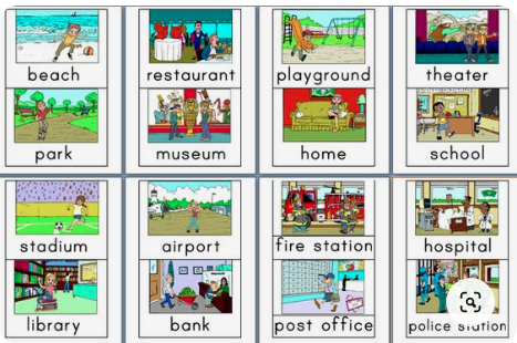
- Choose places of the neighborhood the children know or pre-teach the places for the song – bakery, fire station, store, police station, school etc.
- Prepare photos of each place in neighborhood for all children in the class. These photos will have written the vocabulary in English.
- Prepare slips of paper to match photos and their written vocabulary.
II. Introduction to the Lesson:
Classroom Mural – What we know about the places in our neighborhood

Model Map
- Create a classroom mural titled “What We Know About Places in Our Neighborhood.”
- Display a model map to generate interest in the new classroom theme (might include vehicles, buildings, street signs, etc.).
- Distribute the pictures of each places of the city to all children in the class. Check that they know the English word for their places.
- Engage the students’ cognition about their favorite place in the city.
- Have the student listen to the video of “Sesame Street – “Places in Our Neighborhood”.
- Repeat steps 3, 4, and 5 with the video “Means of transport: The Song.”
III. Step-by-step Procedures for Teaching the Objectives:
- Listen to the video of the book; ” Places in My Neighborhood 1st Grade.”
- Do a Cloze reading procedure with the students as a writing assignment.
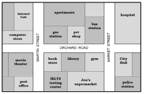
- Form groups of four students. Display a Google Map of Colmenar Viejo with the “Street View.” Students can discover how maps represent street views.
- Teach the students the ordinal numbers (e.g. first, second, etc. to 20th).
- Distribute the block paper and the supplies to construct a 3-dementional map.
- Share with students the expectations of how many buildings must be built, how to name the streets, and how to design the map.
- Teach the students the vocabulary for giving directions (turn, left, right, straight ahead, etc.) through the use of Total Physical Response (TPR). Students will act out the verbal directions of the teacher without responding orally.
- Have students practice giving directions from one place on the map to another place demonstrating their understanding with different types of vehicles.
Google Street View of Tirso de Molina School and Google Map


IV. Closure and Review of the Lesson:
- The students will be assessed on the accuracy of their maps according to the expectations outlined in III. 6.
- At the end of the third day, students will complete an alternative assessment, called The Muddiest Point (Cross and Angelo). Students will be asked to write which concepts of the lesson are the most confusing or unclear. The teacher will read the responses anonymously aloud to the class. The teacher will clarify the misunderstandings.
- Children will give a series of directions in English to other students in their group to go with a specific vehicle from one place on the map to another place. For example, “With the ambulance, go from the fire station to the hospital.” The student receiving the directions will have to narrate their progress as they go from one place to another. For example, “I start at the fire station on Fifth Street. I turn left and go for three blocks. Then, I right on Eighth Street to the hospital.”
- A more advanced assessment- One student gives the set of directions that the other student has to follow without telling them of the final destination to see if the student can arrive at the correct place in the neighborhood.
Assessing Understanding of the Concept Taught
- The students will give a series of directions.
- They will follow correctly someone else’s directions with a car on a 3-dimentional map that the group created. The expectation is that they will achieve the objectives at the 80% level.
Resources:
All Things Topics
https://www.allthingstopics.com/uploads/2/3/2/9/23290220/reading-map-placestown.pdf
English Education Videos
Google Maps
HMH
HugeDomains.com
Sesame Street
We All Learn English
https://wealllearnenglishnatalia.blogspot.com/2013/03/interactive-book-about-shops-and-places.html

This work is licensed under a Creative Commons Attribution-NonCommercial-ShareAlike 4.0 International License.
